HuntData LLC For Sales please Call. 303.663.4878
For support questions, please send us an email the response will be much faster.
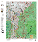
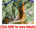
Idaho Mule Deer Land Ownership Maps for Controlled Hunts.
Details
The Land Ownership Maps are built using land ownership data from USGS, National Forest and the State. We add current location data, streams, lakes, roads and trails from the USGS 7.5 minute Quad Map data set then print it on our rugged map fabric to create the best map in the industry. Click on the small map at left to see a larger sample. Scroll to the bottom of the map to order then move to the bottom right to Add To Cart.
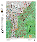
Idaho Moose Unit Maps.
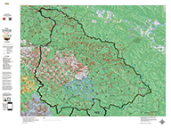
Idaho Mountain Goat Unit Maps.
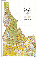
Idaho Statewide Unit Maps.
A Statewide Map depicting land ownership as a base with hunting unit boundary overlays. Great for the den or the shop. Find out which units have the most public land or which units are close.
Life at the Top - Wildlife above Timberline.
Your family will delight in the wonders of nature as a biologist shares his knowledge of the behavior of animals above the timberline.
CO Mountain Goat 3D Google Maps!.
3D Google Earth maps of any Mountain Goat Unit! The maps are exact copies the printed map. Transfer coordinates and make notes on an exact 3D image of your paper map. The maps display kill sites and reported kill drainages from 2003 through last Fall. Kill Sites are color coded by year! Click Here to see a Google Earth demo.
3D Moose Map.
View a map of your Moose unit in 3D on Google Earth! Click Here to see the Statewide GMU Reference Map.
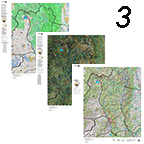
3 Moose Printed Maps - Land Ownership, Satellite, Topo - Save $40.
Get $30 off when you order a BLM Kill Site Map (land ownership), a Satellite Image with Kill Sites, and the 3D image set.
home | about us | products | search | checkout | e-mail | privacy policy
HuntData Copyright 1996-2008 HuntData LLC. Web site Optimization and Design By fmtmwebservices.net & Uswebtek.com