HuntData LLC For Sales please Call. 303.663.4878
For support questions, please send us an email the response will be much faster.
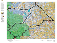
NEW Hybrids! Wyoming Deer Land Ownership and Habitat Hybrid Maps.
Details
A great Mule Deer map built on a landownership base with summer and winter concentrations. The map provides everything you need to figure out not only where you CAN hunt but where you SHOULD hunt. As with all of our Hybrid maps, they are printed on our rugged fabric material. Click Here to see the Wyoming Deer GMU Reference Map.
Digital Maps - Wyoming State Map Set.
A first of its kind. The Statewide Wyoming Map set consists of over 1,100 maps. This includes 3 maps for every Antelope Unit. A Topo map with boundaries, a Land Ownership Map from the BLM, and a first of its kind - a habitat map showing summer range, winter range, and migration routs. View these maps on your desktop or go mobile and load them to your iPhone, iPad, or DROID. A must-have for serious hunters.
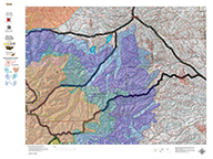
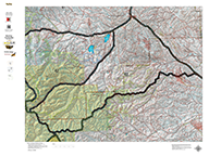
Wyoming Elk Habitat Maps.
Unit boundaries where you can hunt but how do you figure out where you SHOULD? Hunt? We've taken the summer, winter, year-round and migration data from WG&F and projected it on newly updated Topo maps which include 7.5min USGS Roads and Trails from their Quad series. The maps are printed on our new rugged map fabric. Click Here to see the Wyoming Elk GMU Reference Map.
3 Map Combo Special! Land Ownership, Habitat, and Topo, Save $30.
Three maps with the information to show you not only where you CAN hunt but where you SHOULD hunt. Land Ownership, Habitat with Summer and Winter Ranges, and the Traditional Topo Maps. Click Here to see the Wyoming Elk GMU Reference Map.
NEW! Wyoming Elk Land Ownership and Habitat Hybrid.
Over the years this has been our #1 requested map. This year, we used 5 different software processes to create the Colorado Elk Hybrid Map. This map is built on our NEW Land Ownership Maps. We then overlay a 7.5 minute (Quads) road layer from the USGS, add National Forest Roads, add lakes and streams from the USGS and then add the Colorado Parks and Wildlife summer, winter, and resident herd, migration routes and corridors for elk. For Mule Deer, we add summer and winter concentration areas. This map has it all. Its all printed on our rugged map fabric. The fabric has a translucency that brings the colors and information to life! The is truly the most comprehensive map we've produced in the past 25 years. Click on the small map at left to see a larger sample. Then, scroll to the bottom to order. Click Here to see the Wyoming Elk GMU Reference Map.
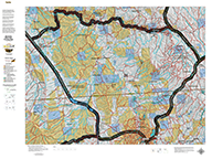
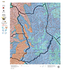
Wyoming Elk Land Ownership.
We took new land ownership data and built these maps from the bottom up. The maps include the USGS roads and trails from their 7.5min Quad Series. The maps are printed on our new rugged map fabric. A great tool to find out where you can hunt. Click Here to see the Wyoming Elk GMU Reference Map.
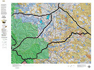
Wyoming Elk Topographical Map.
We rebuilt the entire Topo line. We've updated the roads and trails USGS 7.5 minute Quad series. US Forest Boundaries and State Lands are newly updated and highlights. A great traditional Topo map with enhancements.Click Here to see the Wyoming Elk GMU Reference Map.
Wyoming Mule Deer Habitat Map.
We updated our Topo Maps then added new habitat overlays. The overlays display Summer and Winter Concentration areas in brilliant colors. As with all of our custom maps, these maps are printed on our rugged map fabric. Click Here to see the Wyoming Deer GMU Reference Map.
home | about us | products | search | checkout | e-mail | privacy policy
HuntData Copyright 1996-2008 HuntData LLC. Web site Optimization and Design By fmtmwebservices.net & Uswebtek.com